Currently Available—Current property listingsAverage Listing Price—Current property averageAverage Bedrooms—Current property averageAverage Bathrooms—Current property averageAverage Living Area—Interior living areaAverage Price / Ft²—Current property average
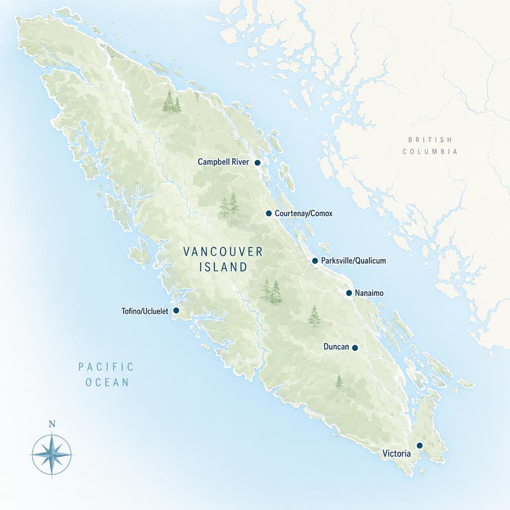
Listings, map and statistics cover every property type in Nanaimo, Lantzville, Nanoose Bay, Parksville, Qualicum Beach, Errington, Coombs, Qualicum Bay, Bowser, Cedar, Gabriola Island, Ladysmith and Chemainus, as listed through the Vancouver Island Real Estate Board. For the rest of the Island north of the Malahat, see Vancouver Island real estate.
Houses, condos, townhomes, waterfront and land for sale on the Island's central east coast, from Ladysmith and Gabriola Island through Nanaimo to Parksville, Qualicum Beach and Bowser.
Real Estate on the Central East Coast of Vancouver Island
Browse current Nanaimo and Parksville real estate: houses, condos, townhomes, waterfront, acreage and land listed through the Vancouver Island Real Estate Board in thirteen communities between Chemainus and Bowser. The area takes in the city of Nanaimo, the seaside towns of Parksville and Qualicum Beach, the farm country of Errington and Coombs, Gabriola Island and the heritage towns of Ladysmith and Chemainus.
Nanaimo is the largest city north of the Malahat and the service centre for the central Island, with the regional hospital, a university, an airport and two BC Ferries terminals to the Lower Mainland. Around it, the market shifts from one community to the next: city neighbourhoods and condo towers, beach towns and golf communities, rural acreage at the foot of Mount Arrowsmith, island homes on wells and rainwater, and hillside streets above Ladysmith Harbour.
Below is an overview of each community, the schools, health care and transport that serve them, and a guide to the eleven property-type pages for the area.
The area follows the east coast of Vancouver Island along the Strait of Georgia, from Chemainus and Ladysmith in the south, past Nanaimo and Lantzville and on to Nanoose Bay, Parksville, Qualicum Beach and the rural shoreline of Qualicum Bay, Bowser and Deep Bay in the north. Errington and Coombs sit inland below Mount Arrowsmith, Cedar and Yellow Point fill the countryside south of Nanaimo, and Gabriola Island lies a short ferry ride off the Nanaimo waterfront.
Local government is a patchwork, and it matters when you buy. Nanaimo, Lantzville, Parksville and Qualicum Beach are municipalities with their own zoning and services. Nanoose Bay, Errington, Coombs, Cedar, Qualicum Bay and Bowser are unincorporated and governed through the Regional District of Nanaimo. Land use on Gabriola is set by the Islands Trust, and Ladysmith and Chemainus belong to the Cowichan Valley Regional District, Chemainus as part of the Municipality of North Cowichan.
Nanaimo, the Harbour City, is built on the traditional lands of the Snuneymuxw First Nation and climbs from its harbour toward Mount Benson. It is where most of the area comes for hospital care, university classes, major shopping and ferries to the mainland. Nanaimo real estate covers the widest range in the region, from downtown condo towers and modest older homes to oceanfront houses on the north-end points.
Downtown, the Old City and Newcastle
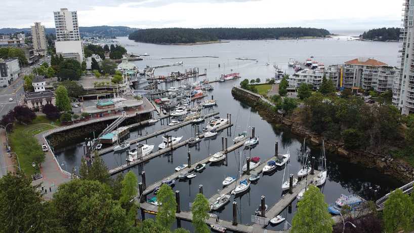
Downtown wraps around the harbour, with the Harbourfront Walkway running past Maffeo Sutton Park, the floatplane docks and the foot-passenger ferry to Saysutshun (Newcastle Island). Above it, the Old City neighbourhood keeps many of the city's early houses on some of its oldest streets, while Newcastle and Brechin Hill look over Newcastle Channel. Condos, character homes and small apartment buildings sit side by side here.
Departure Bay and North Nanaimo
Departure Bay has a beach, the BC Ferries terminal and established homes on the slopes around the bay. Beyond it, Hammond Bay, Rocky Point and Stephenson Point face the open Strait, and Uplands, Pleasant Valley, Linley Valley and the Long Lake area hold many of the city's newer subdivisions and townhome complexes. The Island Highway through the north end is lined with the city's largest shopping centres.
Central and South Nanaimo
The middle of the city takes in Nanaimo Regional General Hospital, the Vancouver Island University campus in the University District, and Harewood, where coal miners were once offered five-acre farms on a rent-to-own basis and many original farmhouses still stand. Farther south, Chase River and Cinnabar Valley have family neighbourhoods close to the Nanaimo Parkway and the Duke Point ferry, and Extension, an old coal-mining village west of the city, keeps a rural feel.
Lantzville and Nanoose Bay
Lantzville, immediately north of Nanaimo, began as a coal-mining town and took its name from Fraser Harry Lantz, who bought the mine. It became the District of Lantzville in 2003 and is almost entirely residential, with a short commercial strip on Lantzville Road, homes on larger lots than most of the city's, and Seaview Elementary for younger students.
Nanoose Bay is an unincorporated community on its own peninsula between Lantzville and Parksville, in the traditional territory of the Snaw-naw-as (Nanoose) First Nation. Much of it is rural, and its best-known neighbourhood is Fairwinds, a planned community laid out around a golf course that opened in 1984 and the Schooner Cove marina, with trails to Enos Lake and Notch Hill. The waters off the peninsula hold the Canadian Forces Maritime Experimental and Test Ranges, a restricted naval testing area in use since 1965.
Parksville and Qualicum Beach
Parksville, named for Nelson Parks, its first postmaster, grew up on the flat land between the Englishman River and French Creek and was incorporated in 1945. Its town centre sits beside Parksville Community Park and a wide sandy beach, and summer visitors, retirees and young families all shape the town. Parksville real estate runs from older ranchers near downtown to newer subdivisions toward the highway, resort condos on the beach and waterfront homes east of town toward Rathtrevor.
Qualicum Beach takes its name from a Pentlatch word for the place where the dog salmon run. A hotel and golf links opened in 1913 and the railway arrived the next year, starting its long run as a resort and retirement town; it was incorporated in 1942. A compact village centre sits up the hill from a waterfront where Highway 19A follows the beach, Milner Gardens and Woodland is run by Vancouver Island University, and Eaglecrest adds a golf-course neighbourhood. Qualicum Beach real estate leans toward single-level homes, patio homes and condos within reach of the village. Between the two towns, the French Creek area and its harbour belong to the regional district rather than either municipality.
Errington, Coombs, Qualicum Bay and Bowser
Inland from Parksville, Errington, Coombs and Hilliers form the farm and small-acreage country of the regional district's Electoral Area F, spread along the Englishman and Little Qualicum rivers below Mount Arrowsmith. Highway 4A runs west through Coombs to join Highway 4 toward Port Alberni, and Errington Elementary serves local families. Many homes here sit on acreage and rely on wells and septic systems rather than town services.
North of Qualicum Beach, Highway 19A follows the shore through Qualicum Bay, Bowser and Deep Bay, the communities of Electoral Area H. The Qualicum First Nation is at the mouth of the Big Qualicum River, Fisheries and Oceans Canada runs a salmon hatchery upstream, and Deep Bay is home to Vancouver Island University's marine field station at the south end of Baynes Sound. Bowser Elementary is the local school, and Horne Lake and Spider Lake are a short drive inland. This is the quietest stretch of the coast, with cottages, rural homes and beachfront rather than subdivisions.
Cedar, Yellow Point and Gabriola Island
South of Nanaimo, the regional district's Electoral Area A covers Cedar, South Wellington, Yellow Point and Cassidy: a countryside of small farms, treed acreages and waterfront along Stuart Channel, crossed by the Nanaimo River. Cedar has its own elementary and secondary schools, and Nanaimo Airport sits at Cassidy beside the Trans-Canada Highway.
Gabriola Island lies about 5 km off Nanaimo, roughly 20 minutes by BC Ferries from the downtown Nanaimo terminal to Descanso Bay. The island is in Snuneymuxw territory; its land use is planned by the Islands Trust through the Gabriola Island Local Trust Committee, while the Regional District of Nanaimo provides regional services. There is no municipal water system, so homes draw on wells, and many also collect rainwater. Gabriola Elementary is on the island.
Ladysmith and Chemainus
Ladysmith climbs a hillside above a sheltered harbour on the 49th parallel. Coal baron James Dunsmuir founded it around the turn of the 20th century to house miners and ship coal from his Extension mine, naming it in 1900 after the relief of Ladysmith in the Boer War, and many early buildings were moved in by rail and by oxen from Extension and Wellington. The heritage storefronts of First Avenue, Transfer Beach Park on the old coal-transfer site and the neighbouring Stz'uminus First Nation all shape the town. Ladysmith real estate includes older homes on steep streets near downtown, newer subdivisions higher up and waterfront on the harbour and Stuart Channel.
Chemainus, a few minutes south, belongs to the Municipality of North Cowichan. A sawmill town for most of its history, it began painting large murals on its buildings in 1982, and when the mill closed in 1983 the murals helped turn the town toward visitors and the arts. BC Ferries sails from Chemainus to Thetis and Penelakut islands, and the town is the one community in this area served by the Cowichan Valley school district.
Hospitals, Schools and Transportation
Health Care
Nanaimo Regional General Hospital is Island Health's main hospital for the central and northern Island, with critical care, maternity, mental health and specialized cardiac care, the region's cancer care centre, and teaching ties to the University of British Columbia. Walk-in urgent care for problems that are not life-threatening is also available at the Oceanside Urgent Care & Health Centre in Parksville and at Island Health's centres in Ladysmith and Chemainus.
Schools and Vancouver Island University
Nanaimo, Lantzville, Cedar, Gabriola Island and Ladysmith are in School District 68 (Nanaimo-Ladysmith), whose secondary schools include Dover Bay, Nanaimo District, Wellington, John Barsby, Cedar Community and Ladysmith secondaries. Parksville, Qualicum Beach, Nanoose Bay, Errington and Bowser are in School District 69 (Qualicum), with Ballenas Secondary in Parksville and Kwalikum Secondary in Qualicum Beach. Chemainus is in School District 79 (Cowichan Valley) and has its own secondary school. Vancouver Island University, which opened as Malaspina College in 1969 and became a university in 2008, has its main campus in Nanaimo.
Ferries, Flights and Highways
BC Ferries links Nanaimo to the Lower Mainland from two terminals: Departure Bay, in the city's north end, sails to Horseshoe Bay in West Vancouver, and Duke Point, south of downtown, sails to Tsawwassen. Floatplanes fly from the downtown waterfront, and scheduled flights use Nanaimo Airport, about 15 minutes south of downtown. Highway 1 runs south over the Malahat to Victoria, the Nanaimo Parkway carries Highway 19 around the city, and at Craig's Crossing near Parksville the Inland Island Highway heads north to the Comox Valley while Highway 19A follows the shore. Highway 4 leads west to Port Alberni and the west coast, and regional transit buses run from Cedar and the airport north to Bowser and Deep Bay.
Parks, Beaches and Recreation
Saysutshun (Newcastle Island Marine) Provincial Park has a 22 km trail network, sandstone cliffs and beaches just across the harbour from downtown Nanaimo. Neck Point and Pipers Lagoon parks put rocky shoreline within the city, Westwood Lake and Colliery Dam parks are minutes from central neighbourhoods, and Mount Benson Regional Park looks out over Nanaimo to the Strait. At Rathtrevor Beach Provincial Park the tide goes out almost a kilometre, and Brant geese stop to feed each spring.
Inland, Englishman River Falls and Little Qualicum Falls provincial parks have waterfalls in forested canyons, Cameron Lake draws swimmers and windsurfers, and Horne Lake Caves and Spider Lake parks sit in the hills behind Qualicum Bay. The Englishman and Little Qualicum river watersheds form the Mount Arrowsmith Biosphere Region, recognized by UNESCO in 2000. South of Nanaimo, Hemer Provincial Park circles Holden Lake with walking and horse trails, and Roberts Memorial Provincial Park reaches sandstone ledges on Stuart Channel. Gabriola adds the Malaspina Galleries and Gabriola Sands, Drumbeg and Sandwell parks.
A Short History of the Area
Coast Salish peoples, among them the Snuneymuxw, Snaw-naw-as, Qualicum, Stz'uminus and Penelakut, lived along this coast long before European settlement. The modern towns grew from coal. The Hudson's Bay Company moved miners to Nanaimo in 1852 and built the Bastion that still stands downtown, and the city was incorporated in 1874. Robert Dunsmuir's Esquimalt and Nanaimo Railway gave Nanaimo its first land link to Victoria in 1886, his son James founded Ladysmith as a coal port, and sawmills built Chemainus.
The railway reached Parksville in 1910 and Qualicum Beach in 1914, opening the Oceanside beaches to holidaymakers and, later, to retirees. As the mines closed one by one, Nanaimo turned to forestry, the port, education and health care, with the Harmac pulp mill opening in 1950. The Nanaimo Parkway opened in 1997, and with the Inland Island Highway it shortened travel up the coast.
Nanaimo and Parksville Real Estate by Property Type
Each property type has its own page with listings, a map, statistics and a market report.
Houses
Detached homes make up the largest share of listings, from Nanaimo subdivisions and Ladysmith's hillside streets to Parksville ranchers and rural homes in Cedar and Errington. Browse Nanaimo and Parksville houses for sale.
Condos
Apartment condos are concentrated in downtown and north Nanaimo, Parksville and Qualicum Beach, with newer buildings at Fairwinds and a smaller supply in Ladysmith and Chemainus. See Nanaimo and Parksville condos for sale.
Townhomes
Townhouses and single-level patio homes are common in north Nanaimo, Parksville and Qualicum Beach, with more in Ladysmith and Chemainus. See Nanaimo and Parksville townhomes for sale.
Waterfront
Oceanfront ranges from sheltered Ladysmith Harbour and Yellow Point to rocky north Nanaimo, the Nanoose headlands and the sandy Oceanside beaches, with some lake, river and Gabriola frontage too. Browse Nanaimo and Parksville waterfront properties.
View Homes
Hillside homes face the Strait and the mainland peaks, Nanaimo's harbour, or Mount Benson and Mount Arrowsmith inland. See Nanaimo and Parksville view homes.
Luxury Homes
Homes listed at $2 million and above are mostly oceanfront or large-acreage properties in Nanoose Bay, north Nanaimo, Lantzville, Qualicum Beach and Yellow Point. See Nanaimo and Parksville luxury homes.
Acreages and Land
Properties of one acre or more, including bare land, are spread through Cedar and Yellow Point, Errington and Coombs, Nanoose Bay, Bowser and Gabriola. Browse Nanaimo and Parksville acreages and land.
Age-restricted communities are a large part of the Parksville, Qualicum Beach and Nanoose Bay markets, with more in north Nanaimo and Chemainus. Browse Nanaimo and Parksville 55+ properties.
Manufactured Homes
Manufactured and mobile homes, in parks or on their own land, are found in several Nanaimo neighbourhoods and in Lantzville, Nanoose Bay, Errington, Coombs and the Parksville area. See Nanaimo and Parksville manufactured homes.
Homes with Suites
Houses with an existing or potential suite suit buyers who want rental income or room for family, especially near the university and the hospital in Nanaimo. See Nanaimo and Parksville homes with suites.
Comox Valley, Campbell River and the Rest of the Island
Before you write an offer, confirm which local government the property falls under (a city or town, a regional district electoral area, the Islands Trust on Gabriola, or North Cowichan in Chemainus), since zoning, permits and services differ; whether water and sewer are municipal or come from a well and septic system; the school catchment; and, if the home will sit empty for part of the year, whether it is in Nanaimo, Lantzville, Parksville, Qualicum Beach, Ladysmith or North Cowichan, where BC's speculation and vacancy tax applies. The home buying guide covers the steps of a purchase.
Search Nanaimo & Parksville MLS® Listings
Use the listings and map at the top of this page to compare houses, condos, townhomes, waterfront and land from Chemainus to Bowser, or open any of the property-type pages above for a narrower search. Area-wide prices, inventory and market times are in the Nanaimo and Parksville Market Report.




 Houses
 Condos
 Townhomes
 Waterfront
 View Homes
 Luxury Homes
 Acreages & Land
 Pet-Friendly
 55+ Homes
 Manufactured
 Homes with Suites
 All Vancouver Island