Currently Available—Current regional listingsAverage Listing Price—Current regional averageAverage Bedrooms—Current regional averageAverage Bathrooms—Current regional averageAverage Living Area—Interior living areaAverage Price / Ft²—Current regional average
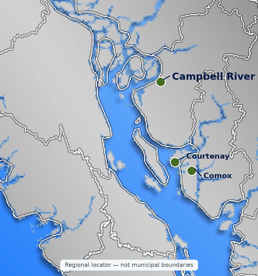
Listings, map and statistics cover every property type in Courtenay, Comox, Cumberland, Royston, Union Bay, Fanny Bay, Merville, Black Creek, Denman Island, Hornby Island, Campbell River and Quadra Island, as listed through the Vancouver Island Real Estate Board. Bowser and Qualicum Beach are covered on the Nanaimo and Parksville real estate page.
Homes, condos, waterfront and land in Courtenay, Comox, Cumberland, the rural valley, Denman and Hornby islands, Campbell River and Quadra Island, between the Strait of Georgia and Strathcona Park.
Browse current Comox Valley real estate and Campbell River homes for sale: houses, condos, townhomes, waterfront, view homes, acreages and land listed on the MLS® along the central east coast of Vancouver Island, from Fanny Bay on Baynes Sound north to Campbell River and Quadra Island.
The search covers two neighbouring markets. The Comox Valley takes in the City of Courtenay, the Town of Comox, the Village of Cumberland and the rural communities and islands of the Comox Valley Regional District. Campbell River, about 50 kilometres north on Highway 19, is a separate city in the Strathcona Regional District with its own school district and airport, and it is the ferry port for Quadra Island.
The two share a hospital system, a college and a coastline that runs from the sheltered shellfish beaches of Baynes Sound to the fast tidal water of Discovery Passage, with the peaks of Strathcona Provincial Park behind. Housing, servicing and local rules change from one community to the next.
Most homes sit on a coastal lowland between the Strait of Georgia and the Beaufort Range: Courtenay and Comox form the urban core, Cumberland sits at the foot of the mountains, and farms and beach communities fill the coast from Baynes Sound to the Oyster River. North of the Oyster River, Campbell River stretches along Discovery Passage, with Quadra Island a short ferry ride across the water.
Courtenay is the largest city in the Comox Valley and its commercial centre, and Courtenay real estate covers the widest range of housing in the valley. The city grew where the Puntledge and Tsolum rivers meet to form the short Courtenay River, which flows into Comox Harbour, and the river still divides the city in two. The west side holds downtown, Lewis Park and Simms Millennium Park on the river, the Courtenay Riverway walk along the estuary, and the Courtenay and District Museum, which displays the 80-million-year-old elasmosaur found on the banks of the Puntledge River in 1988.
East Courtenay, across the river, is where most of the city's recent growth has gone: newer subdivisions, townhome complexes and condos around Ryan Road and Lerwick Road, North Island Hospital's Comox Valley campus and North Island College. Crown Isle, a golf community in East Courtenay, adds detached homes, villas and condos around its fairways. On the city's western and northern edges, the Arden and Lake Trail areas and the roads toward Merville mix larger lots and acreages with older subdivisions.
The Comox Valley Exhibition Grounds host the annual Comox Valley Exhibition and Vancouver Island MusicFest. Courtenay is also the northern end of the Esquimalt and Nanaimo Railway, which now carries freight only; passenger service was suspended in 2011.
Comox Real Estate
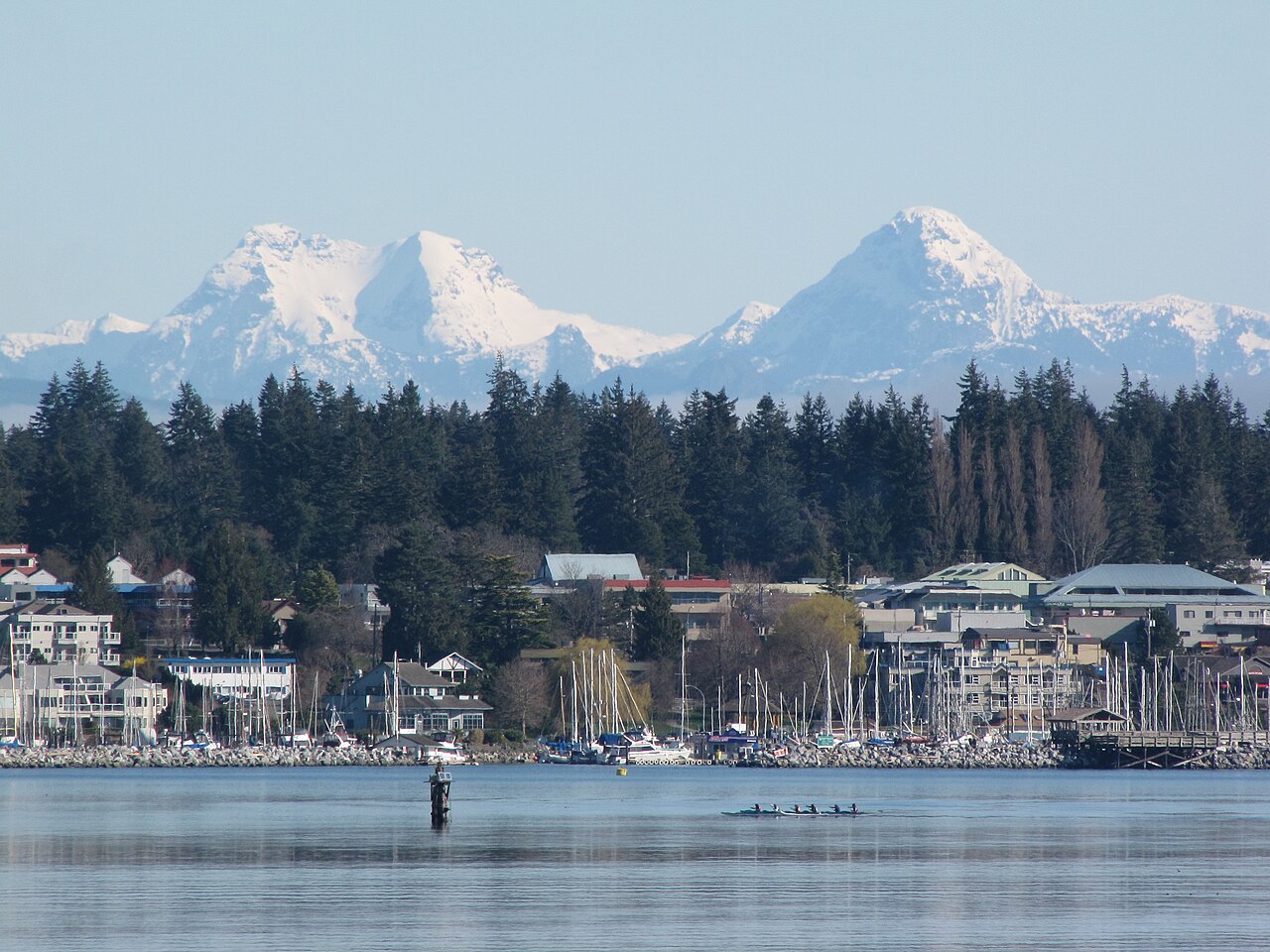
The Town of Comox occupies the south shore of the Comox Peninsula, facing Comox Harbour and, across the water, the Beaufort Range and the Comox Glacier, known to the K'ómoks as Queneesh. Comox Avenue is the main street, running down to the marina, Marina Park and the harbour walk, and Filberg Heritage Lodge and Park keeps a timber lodge and its gardens open to the public on the shore.
The town is shaped by 19 Wing Comox, the air force base north of town that shares its runways with the Comox Valley Airport, and base postings bring a regular flow of military families. Comox real estate runs from older homes near the harbour and family neighbourhoods built in the 1960s to 1980s to newer streets on the north side of town, and Highland Secondary serves the town's high-school students.
Beyond the town boundary, the rural peninsula holds Lazo, Point Holmes, Kye Bay and Little River, where BC Ferries sails to Powell River. Goose Spit, the sand spit that encloses Comox Harbour, is a regional park, and Seal Bay Nature Park protects forest running down to the Strait of Georgia north of the town.
Cumberland Real Estate
Cumberland began as the company town of the Union Colliery, the coal operation Robert Dunsmuir took over in 1887, and it took the Cumberland name when it incorporated as a city in 1898. It reincorporated as a village in 1958. In the mining years the district had one of the largest Chinese communities in Canada and a Japanese settlement west of the townsite. Coal mining in the district ended in 1966, and the Cumberland Museum and Coal Creek Historic Park keep that history in view.
The village is now known for the forest trails above it. The Village manages the Cumberland Community Forest Park, assembled from land bought by the Cumberland Community Forest Society, along with its watershed lands, while trails on neighbouring private forest land are open under an agreement between the landowners, the Village and the local riding club. Heritage storefronts on Dunsmuir Avenue, small miners' cottages and newer subdivisions make up the housing, with Comox Lake and the Cumberland Lake Park campground a few minutes west.
Royston, Union Bay, Fanny Bay, Merville and Black Creek
South of Courtenay, Highway 19A follows the shore of Baynes Sound, the channel between Vancouver Island and Denman Island. Royston faces the head of Comox Harbour, where the hulls of more than a dozen old ships, sunk as a breakwater for log booms from the late 1930s onward, still show at low tide. Union Bay was the shipping port for Cumberland's coal from 1889, and its restored post office and old jail survive along the highway. Fanny Bay and Buckley Bay, the ferry terminal for Denman Island, complete the shoreline.
Baynes Sound produces a large share of the oysters and clams farmed in British Columbia, and much of its foreshore is leased for shellfish growing. These communities sit in the Comox Valley Regional District's Electoral Area A, with rural zoning, larger lots, and wells or small water systems in many places.
North of Courtenay, Merville was founded in 1919 as a settlement for returning First World War soldiers and named after a town in France where Canadian troops had been headquartered; a fire in 1922 destroyed many of its farms. Merville and Black Creek, in Electoral Area C, are farm and forest country, and their shoreline includes Kitty Coleman Beach Provincial Park, Miracle Beach Provincial Park and the long sand of Saratoga Beach. The Oyster River marks the northern edge of the Comox Valley Regional District.
Denman and Hornby Islands
Denman Island lies across Baynes Sound from Buckley Bay, a short BC Ferries crossing, and Hornby Island is reached by a second ferry from Gravelly Bay on Denman's east side to Shingle Spit. Land use on both islands is planned by the Islands Trust through local trust committees, with regional services from the Comox Valley Regional District.
Denman is mostly forest, farms and rural homes, with the beach and old forest of Fillongley Provincial Park and the trail to Boyle Point at its south end. Hornby draws summer visitors to the sandy beach at Tribune Bay, the bluffs of Helliwell Provincial Park and the trails of Mount Geoffrey. Denman Island Community School runs to Grade 7 and Hornby Island's school to Grade 9, so older students continue off-island or through distance education. Homes depend on wells, rainwater and septic systems, and ferry schedules shape daily life.
Campbell River Real Estate
Campbell River sits at the south end of Discovery Passage, the narrow channel between Vancouver Island and Quadra Island that carries Inside Passage traffic north. Incorporated in 1947, the city grew with the John Hart Generating Station on the Campbell River, built that year and replaced by an underground powerhouse in 2018, and with logging, fishing and the Elk Falls Mill, which closed in 2009. Sport fishing earned it the name Salmon Capital of the World, and Discovery Pier, Canada's first saltwater fishing pier, still draws anglers.
Campbell River real estate follows the shoreline. Willow Point and Campbell River South, at the south end, combine established family streets, newer subdivisions and ocean-view homes. Central Campbell River holds downtown, the hospital campus and older neighbourhoods on the slopes above the water, and Campbellton, by the river mouth where Highway 28 begins, is one of the oldest parts of town. Campbell River West adds newer subdivisions inland, and Campbell River North runs up the passage toward Seymour Narrows, where the 1958 Ripple Rock blast removed a notorious hazard to shipping.
The 10-kilometre Rotary Seawalk runs along the Discovery Passage shore, Highway 28 leads west past Elk Falls Provincial Park and its suspension bridge to Strathcona Provincial Park and Gold River, and Highway 19 continues north to Port Hardy. Unlike Courtenay, Comox and Cumberland, Campbell River is not one of the municipalities covered by BC's speculation and vacancy tax.
Quadra Island
BC Ferries crosses from downtown Campbell River to Quathiaski Cove, the commercial centre of Quadra Island. Heriot Bay on the east side has the ferry to Cortes Island and sits beside Rebecca Spit Marine Provincial Park, and Cape Mudge Village at the south end is home to the We Wai Kai Nation and the Nuyumbalees Cultural Centre, which holds a potlatch collection returned to the community. Quadra is in the Strathcona Regional District and School District 72, and housing runs from village lots to remote waterfront at the north end.
Hospitals, Schools and Services
The North Island Hospital opened two campuses in 2017: the Comox Valley campus on Lerwick Road in Courtenay and the Campbell River campus. Each has a 24-hour emergency department. North Island College teaches university transfer, trades, health and business programs at its Comox Valley campus on Ryan Road and its Campbell River campus, along with campuses in Port Alberni and Port Hardy.
School District 71 (Comox Valley) runs public schools in Courtenay, Comox, Cumberland, the rural valley and on Denman and Hornby islands, with secondary schools including Georges P. Vanier and Mark R. Isfeld in Courtenay and Highland in Comox. School District 72 (Campbell River) serves the city and Quadra Island, with Carihi and Timberline secondaries and two middle schools. Catchments are set by address, so confirm the school for a specific property with the district.
Airports, Ferries and Highways
The Comox Valley Airport (YQQ) uses the airfield of 19 Wing Comox, a few minutes from Comox and Courtenay, with scheduled flights to Vancouver, Calgary and Edmonton and seasonal routes farther afield. Campbell River Airport (YBL) on Jubilee Parkway is owned and operated by the city and has daily flights to Vancouver.
Highway 19, the Inland Island Highway, links Campbell River and the Comox Valley with Nanaimo, where BC Ferries sails to the Lower Mainland from Departure Bay and Duke Point. Highway 19A, the older Island Highway, follows the coast through Fanny Bay, Union Bay, Royston, Courtenay, Merville and Black Creek into Campbell River. Local ferry routes connect Comox (Little River) with Powell River, Buckley Bay with Denman Island, Denman with Hornby Island, Campbell River with Quadra Island, and Quadra's Heriot Bay with Cortes Island.
Mountains, Parks and the Water
Mount Washington Alpine Resort, which opened in 1979 above the Comox Valley, is the area's ski hill and summer mountain resort, and its Paradise Meadows trailhead leads onto the Forbidden Plateau in Strathcona Provincial Park. Strathcona, British Columbia's first provincial park, holds the Golden Hinde, the Island's highest point, and Highway 28 leads from Campbell River to Buttle Lake.
Closer to home are the Cumberland trails, Seal Bay, Goose Spit, the beaches at Kye Bay and Miracle Beach, Elk Falls and the parks of the three islands, along with salmon fishing and boating out of Comox Harbour and Campbell River.
A Short History of the Area
The Comox Valley is the traditional territory of the K'ómoks First Nation, and the name Comox comes from kw'umuxws, a word meaning plentiful. Campbell River and Quadra Island are home to the Wei Wai Kum and We Wai Kai nations, Laich-Kwil-Tach peoples of Discovery Passage.
Farm settlers arrived in the valley in 1861, encouraged by colonial governor James Douglas, and until the 1890s the valley could be reached only by sea. Coal brought the next wave: the Union Colliery opened mines at Cumberland and in 1889 completed a railway to its wharves at Union Bay. Large-scale logging followed, led by the Comox Logging and Railway Company. The railway from Nanaimo reached Courtenay in 1914, and the city incorporated on January 1, 1915. The Royal Air Force built the airfield at Comox in 1942, and it became today's 19 Wing.
Campbell River grew after the Second World War, when the John Hart station and the Elk Falls Mill brought jobs. In 1958 the blast at Ripple Rock in Seymour Narrows, one of the largest non-nuclear planned explosions on record, made the passage north of the city safer for ships.
Comox Valley Real Estate by Property Type
Houses
Detached houses are the largest part of the market, from older homes near downtown Courtenay and in Campbellton to new subdivisions in East Courtenay, Comox and Campbell River, and rural houses in Merville, Black Creek and on the islands. Browse Comox Valley and Campbell River houses for sale.
Condos
Condos cluster in East Courtenay, near the harbour in Comox and along Campbell River's Island Highway, with ski-area condos in the alpine village at Mount Washington. Browse Comox Valley and Campbell River condos for sale.
Townhomes
Townhome complexes are concentrated in East Courtenay, Comox and central Campbell River, with newer projects in Campbellton and on the west side of Campbell River. Browse Comox Valley and Campbell River townhomes for sale.
Views take in the Comox Glacier and the Beaufort Range, the Strait of Georgia and the Coast Mountains, and Quadra Island across Discovery Passage. Browse Comox Valley and Campbell River view homes.
Luxury Homes
Homes listed at $2 million and above include oceanfront on the Comox Peninsula and the north valley beaches, golf-course homes, and estates on Quadra Island and Discovery Passage. Browse Comox Valley and Campbell River luxury homes.
Acreages and Land
Choices include farmland in Merville and Black Creek, rural parcels around Courtenay and Campbell River, and island acreage on Denman, Hornby and Quadra. Browse Comox Valley and Campbell River acreages and land.
Pet-Friendly Condos and Townhomes
Strata bylaws decide whether cats and dogs are allowed, and many local buildings and complexes permit them. Browse pet-friendly condos and townhomes.
55+ Homes
Age-restricted condos, townhomes and manufactured home communities in Courtenay, Comox and Campbell River serve buyers 55 and over. Browse 55+ condos, townhomes and manufactured homes.
Manufactured Homes
Manufactured homes sit in parks in Courtenay, Comox and Campbell River and on their own land in Union Bay, Black Creek and other rural areas. Browse Comox Valley and Campbell River manufactured homes.
Confirm which government regulates the property: the City of Courtenay, the Town of Comox, the Village of Cumberland, the City of Campbell River, a Comox Valley or Strathcona regional district electoral area, or the Islands Trust on Denman and Hornby. That decides zoning, servicing, permits, the school district and whether BC's speculation and vacancy tax applies. The home buying guide walks through each stage of a BC purchase.
Search Comox Valley & Campbell River MLS® Listings




 Houses
 Condos
 Townhomes
 Waterfront
 View Homes
 Luxury Homes
 Acreages & Land
 Pet-Friendly
 55+ Homes
 Manufactured
 Homes with Suites
 All Vancouver Island